أحد أفضل كتب الGIS على الشبكة مجاناً
كتاب Geographic Information Systems, First Edition, 1991
كتاب Geographic Information Systems, First Edition, 1991
هو أحد أهم المراجع في مجال نظم المعلومات الجغرافية ، والذي لا قى رواجاً كبياً ويقع هذا الكتاب في مجلدين سعر الأصدار الثاني منه أكثر من (400 دولار) .
قام الناشربعد صدور النسخة الثانية من هذا الكتاب بوضع 35 فصلاً من الإصدار الأول للكتاب على الإنترنت مجاناً على هذا الرابط
Geographic Information Systems, First Edition, 1991 | |
| ---------- | |
| VOLUME 1 : PRINCIPLES | |
| ---------- | |
| Preface | xiii |
| List of contributors | xvii |
| Acknowledgements | xxvii |
| ---------- | |
| Section I Overview | |
| ---------- | |
| Introduction | 3-7 |
| D J Maguire, M F Goodchild and D W Rhind | |
| 1. An overview and definition of GIS | 9-20 |
| D J Maguire | |
| 2. The history of GIS | 21-43 |
| J T Coppock and D W Rhind | |
| 3. The technological setting of GIS | 45-54 |
| M F Goodchild | |
| 4. The commercial setting of GIS | 55-65 |
| J Dangermond | |
| 5. The government setting of GIS in the United Kingdom | 67-79 |
| R Chorley and R Buxton | |
| 6. The academic setting of GIS | 81-90 |
| D J Unwin | |
| 7. The organizational home for GIS in the scientific professional community | 91-100 |
| J L Morrison | |
| 8. A critique of GIS | 101-7 |
| R T Aangeenbrug | |
| ---------- | |
| Section II Principles | |
| ---------- | |
| Introduction | 111-17 |
| M F Goodchild, D W Rhind and D J Maguire | |
| (a) Nature of spatial data | |
| 9. Concepts of space and geographical data | 119-34 |
| A C Gatrell | |
| 10. Coordinate systems and map projections for GIS | 135-46 |
| D H Maling | |
| 11. Language issues for GIS | 147-63 |
| A U Frank and D M Mark | |
| 12. The error component in spatial data | 165-74 |
| N R Chrisman | |
| 13. Spatial data sources and data problems | 175-89 |
| P F Fisher | |
| 14. GIS and remote sensing | 191-213 |
| F W Davis and D S Simonett | |
| Color Plates 14-1a, 14-1b | |
| (b) Digital representation | |
| 15. Computer systems and low-level data structures for GIS | 215-25 |
| Wm R Franklin | |
| 16. High-level spatial data structures for GIS | 227-37 |
| M J Egenhofer and J R Herring | |
| 17. GIS data capture hardware and software | 239-49 |
| M J Jackson and P A Woodsford | |
| Color Plates 17-1, 17-2, 17-3, 17-4, 17-5, 17-6, 17-7, 17-8, 17-9, 17-10 | |
| 18. Database management systems | 251-67 |
| R G Healey | |
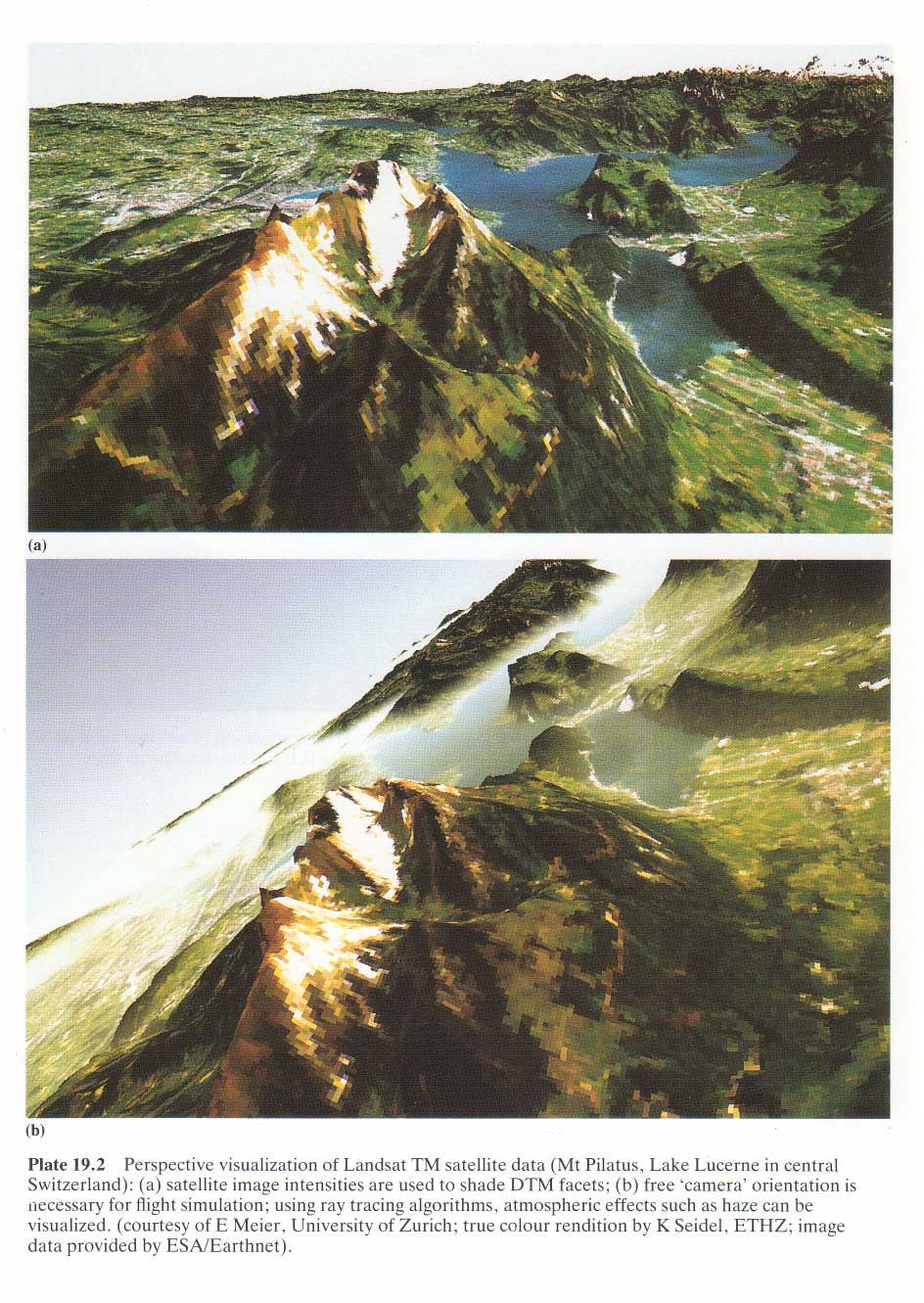
| 19. Digital terrain modelling | 269-97 |
| Color Plates 19-1, 19-2ab, 19-3, 19-4, 19-5 | |
| R Weibel and M Heller | |
| 20. Three-dimensional GIS | 299-317 |
| J F Raper and B Kelk | |
| (c) Functional issues | |
| 21. The functionality of GIS | 319-35 |
| D J Maguire and J Dangermond | |
| 22. Information integration and GIS | 337-60 |
| I D H Shepherd | |
| 23. Cartographic modelling | 361-74 |
| C D Tomlin | |
| 24. Spatial data integration | 375-87 |
| R Flowerdew | |
| 25. Developing appropriate spatial analysis methods for GIS | 389-402 |
| S Openshaw | |
| 26. Spatial decision support systems | 403-12 |
| P J Densham | |
| 27. Knowledge-based approaches in GIS | 413-25 |
| T R Smith and Ye Jiang | |
| (d) Display issues | |
| 28. Visualization | 427-43 |
| B P Buttenfield and W A Mackaness | |
| 29. Computer name placement | 445-56 |
| H Freeman | |
| 30. Generalization of spatial databases | 457-75 |
| J-C Muller | |
| (e) Operational issues | |
| 31. GIS specification, evaluation and implementation | 477-88 |
| A L Clarke | |
| 32. Legal aspects of GIS | 489-502 |
| E F Epstein | |
| 33. Managing an operational GIS: the UK National On-Line Manpower Information System (NOMIS) | 503-13 |
| M J Blakemore | |
| 34. Spatial data exchange and standardization | 515-30 |
| S C Guptill | |
| Consolidated bibliography | 531-591 |
| List of acronyms | 593-598 |
| Author index | 599-613 |
| Subject index | 615-649 |
| ---------- | |
| VOLUME 2 : APPLICATIONS | |
| ---------- | |
| Preface | xiii |
| List of contributors | xvii |
| Acknowledgements | xxvii |
| ---------- | |
| Section III Applications | |
| ---------- | |
| Introduction | 3-10 |
| D W Rhind, D J Maguire and M F Goodchild | |
| (a) National and international GIS programmes | |
| 35. A USGS perspective on GIS | 11-22 |
| L E Starr and K E Anderson | |
| 36. Development of GIS-related activities at the Ordnance Survey | 23-38 |
| M Sowton | |
| 37. National GIS programmes in Sweden | 39-46 |
| L Ottoson and B Rystedt | |
| 38. The development of GIS in Japan | 47-56 |
| S Kubo | |
| 39. Land and Geographical Information Systems in Australia | 57-70 |
| J F O'Callaghan and B J Garner | |
| 40. GIS and developing nations | 71-84 |
| D R F Taylor | |
| (b) Socio-economic applications | |
| 41. Land information systems | 85-99 |
| P F Dale | |
| 42. GIS and utilities | 101-14 |
| R P Mahoney | |
| 43. Car navigation systems | 115-25 |
| M White | |
| 44. Counting the people: the role of GIS | 127-37 |
| D W Rhind | |
| 45. GIS and market analysis | 139-51 |
| J R Beaumont | |
| (c) Environmental applications | |
| 46. Soil information systems | 153-69 |
| P A Burrough | |
| Color Plates 46-1, 46-2, 46-3 | |
| 47. Integration of geoscientific data using GIS | 171-84 |
| G F Bonham-Carter | |
| 48. Multisource, multinational environmental GIS: lessons learnt from CORINE | 185-200 |
| H M Mounsey | |
| 49. Environmental databases and GIS | 201-16 |
| J R G Townshend | |
| Color Plates 49-1, 49-2, 49-3, 49-4ab, 49-5, 49-6, 49-7 | |
| 50. Global databases and their implications for GIS | 217-31 |
| D M Clark, D A Hastings and J J Kineman | |
| (d) Management applications | |
| 51. GIS and public policy | 233-45 |
| H W Calkins | |
| 52. Urban GIS applications | 247-60 |
| R Parrott and F P Stutz | |
| Color Plates 52-1abcd | |
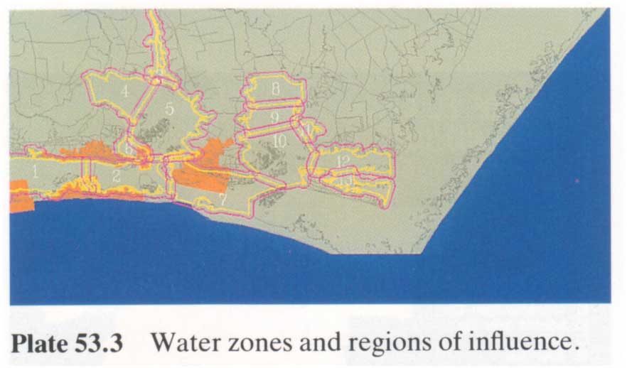
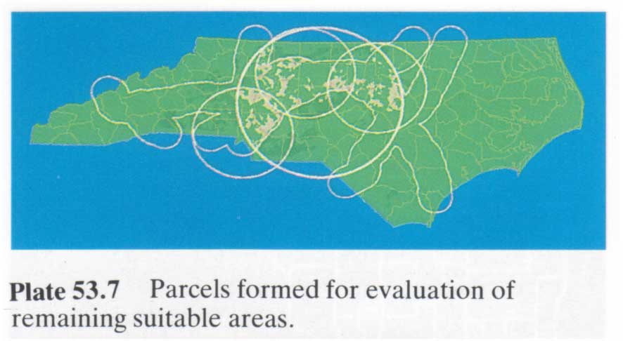
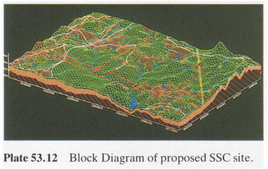
| 53. Land resource information systems | 261-73 |
| K C Siderelis | |
| Color Plates 53-1, 53-2, 53-3, 53-4, 53-5, 53-6, 53-7, 53-8, 53-9, 53-10, 53-11, 53-12 | |
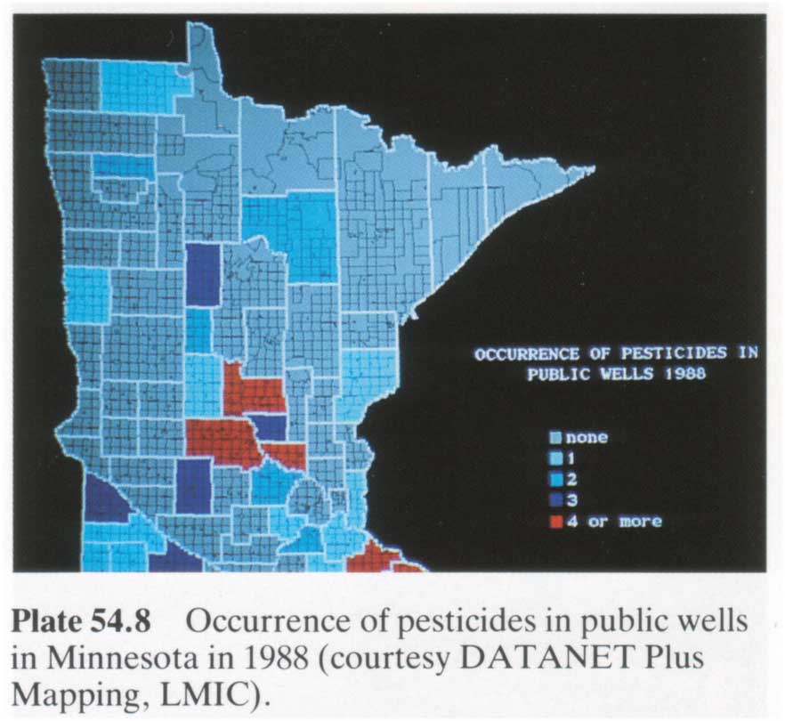
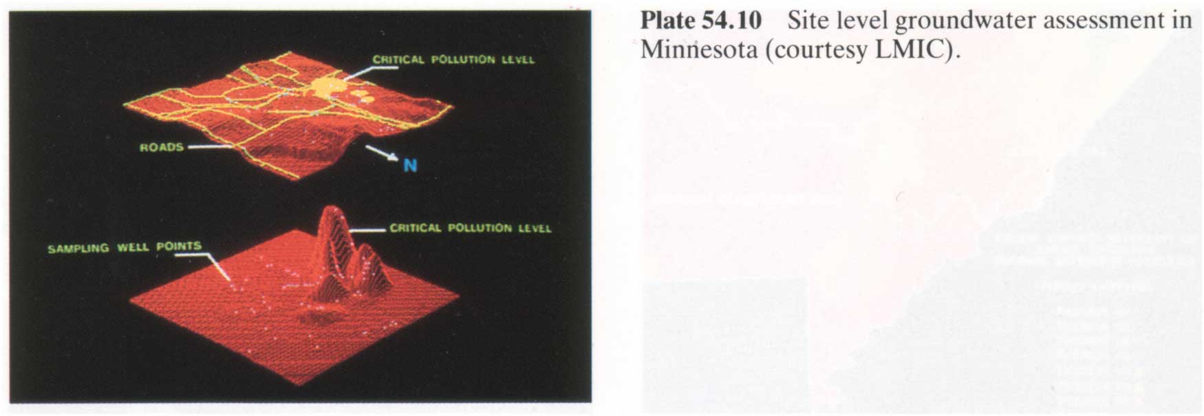
| 54. Land management applications of GIS in the state of Minnesota | 275-83 |
| A Robinette | |
| Color Plates 54-1, 54-2, 54-3, 54-4, 54-5, 54-6, 54-7, 54-8, 54-9, 54-10, 54-11, 54-12, 54-3, 54-14 | |
| 55. GIS in island resource planning: a case study in map analysis | 285-95 |
| J K Berry | |
| Color Plates 55-1, 55-2, 55-3, 55-4, 55-5, 55-6, 55-7 | |
| 56. Integrated planning information systems | 297-310 |
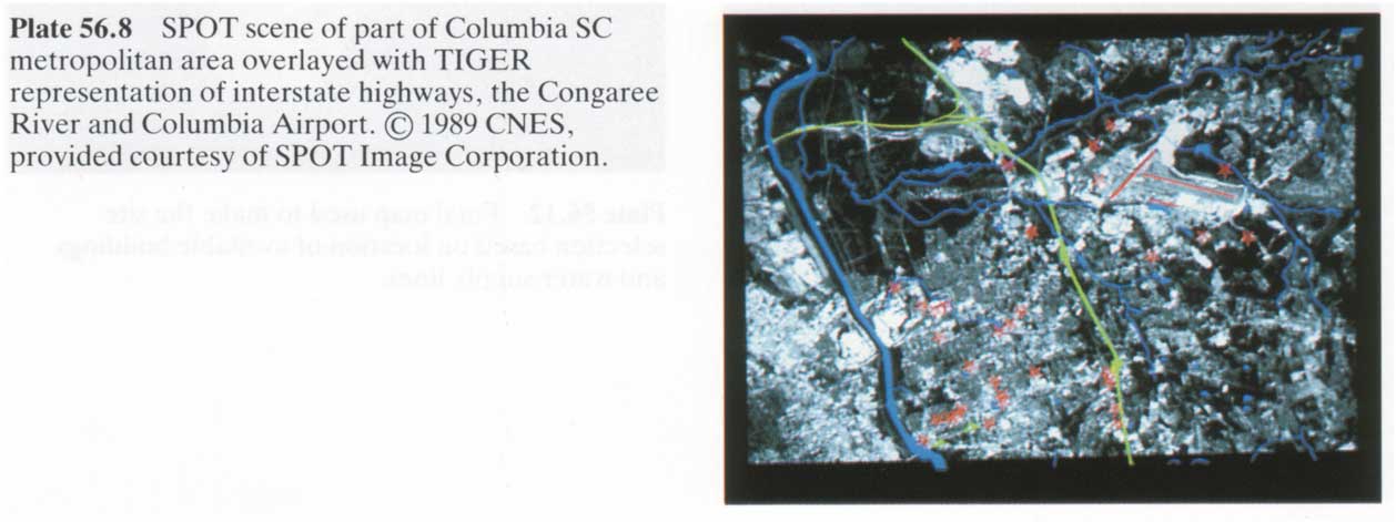
| D J Cowen and W L Shirley | |
| Color Plates 56-1, 56-2, 56-3, 56-4, 56-5, 56-6, 56-7, 56-8, 56-9, 56-10, 56-11, 56-12 | |
| ---------- | |
| Section IV Epilogue | |
| ---------- | |
| Epilogue | 313-27 |
| D W Rhind, M F Goodchild and D J Maguire | |
| Consolidated bibliography | 329-389 |
| List of acronyms | 391-396 |
| Author index | 397-411 |
| Subject index | 413-447 |
ليست هناك تعليقات:
إرسال تعليق